I did quite a lot of on-line research into artists who have used maps in their work, in all kinds of ways. I had also looked at several books about maps in art. The range of material is enormous and I really don't now quite how to start. So I was glad to have chance to discuss my ideas so far in a tutorial with mar. That helped me focus on several ideas: to think of a pam as an abstract thing, as well as an interpretation of a single place; to think about scale - can I work on a larger scale than previously?; and to think about the process of making a map, as well as the finished object.
I came away with even more references to look up, including these:
Dennis Woods, a cartographer who thinks about the meaning of maps, why we need them, what kind of thing they can tell us. He makes maps about the community and the people who live in his neighbourhood, as well as the purely geographic.

He has done a whole series of such maps published in his book Everything Sings
Link here to a review of his book Everything Sings, http://www.sigliopress.com/ltdEd/atlas.htm
and has also produced technical books on how to make modern maps with digital technology.

http://jorgemacchi.com/eng/obra15.htm
Vidas paralelas(parallel lives)
1998
Two sheets of glass.
60 x 80 cm each.
1998
Two sheets of glass.
60 x 80 cm each.
Guía de la inmovilidad2003
Buenos Aires sreet guide. 20 x 28 cm
Buenos Aires sreet guide. 20 x 28 cm
Amsterdam
2004
Mapa de Amsterdam intervenido.
100 x 110 cm
2004
Mapa de Amsterdam intervenido.
100 x 110 cm
In Liliput2007
Collage. 130 x 180 cm In Liliput The countries taken out from a world map are placed by chance on a white paper as if they had fallen down from a certain height. This fall has not affected just the position but the scale of the countries in the representation: a relative distances chart drawn on the white paper establishes the new distances in millimetres.
I like the way Macchi's work focuses on the elements of mapping, without attempting to produce a map of anywhere in particular. This is what I am trying to achieve in my own work for the Place/Site/Map project.
Kathy Prendergast, born in Dublin in 1958, and now lives and works in London, and has done a lot of work involving maps and mapping. Her major work, The City Drawings, has been a series of 113 pencil drawings of maps of all the capital cities of the world. In addition she has done all kinds of other draw maps of cities, such as these, two of a series of road maps of Minnesota. There are more of her images on my blog later on, and here.
Minnesota Road Map XXIII, 2005
Minnesota Road Map XXIX, 2005
City Drawings, London 1997
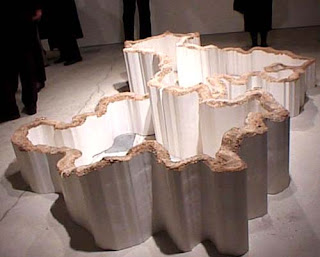
Tania Kovats has done a lot of varied work on landscape and maps, including wonderful things like the White Cliffs of Dover, (2000), a relief to hang on a domestic wall;
More about this is available on the V and A website here.

Another of her pieces, relevant to the theme of Maps, is a living contour sculpture planted along the bottom of a small valley in Devon. The piece is described thus:
Tania Kovats is known for her interest in the different ways that our culture represents and mediates nature. She has recreated fictional landscapes, from visions of Utopia to scenes of natural disaster.
Crockerton Combe is a quiet and secluded valley. Its sides have never been ploughed and it plays host to numerous wild plants and flowers. It is noticeably different from the heavily farmed surrounding environment. This difference combined with its topography lends the valley a sense of enclosure and peace which allows it to borrow ‘garden’ status.
Planting a crop of oats in a single strip following the contour along the base of the valley, an area that has been cultivated in the past, Tania made her largest work to date, using the natural landscape.
With kind permission of Clare Farrow and the Ministry of Agriculture, Fisheries and Food.
I really like her work, it's original, interesting, varied and witty.


No comments:
Post a Comment